


Refuge des Aiguilles d'Arves par les Verneys Valloire

verotrail
User
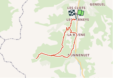

Length
16.1 km

Max alt
2243 m

Uphill gradient
1010 m
Km-Effort
30 km

Min alt
1567 m

Downhill gradient
1012 m
Boucle
Yes
Creation date :
2019-04-08 11:52:19.524
Updated on :
2019-04-08 11:53:28.902
--
Difficulty : Difficult

FREE GPS app for hiking
 SityTrail
IGN / Geographical institutes
SityTrail Plus
The world is yours!
About
Trail On foot of 16.1 km to be discovered at Auvergne-Rhône-Alpes, Savoy, Valloire. This trail is proposed by verotrail.
Positioning
Country:
France
Region :
Auvergne-Rhône-Alpes
Department/Province :
Savoy
Municipality :
Valloire
Location:
Unknown
Start:(Dec)
Start:(UTM)
297093 ; 5002660 (32T) N.
Comments