


RSL 011

jynenault
User
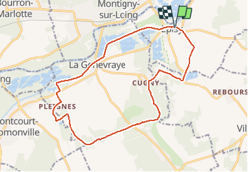

Length
17.7 km

Max alt
95 m

Uphill gradient
175 m
Km-Effort
20 km

Min alt
50 m

Downhill gradient
174 m
Boucle
Yes
Creation date :
2014-12-10 00:00:00.0
Updated on :
2014-12-10 00:00:00.0
5h00
Difficulty : Very easy

FREE GPS app for hiking
 SityTrail
IGN / Geographical institutes
SityTrail Plus
The world is yours!
About
Trail Walking of 17.7 km to be discovered at Ile-de-France, Seine-et-Marne, Moret-Loing-et-Orvanne. This trail is proposed by jynenault.
Positioning
Country:
France
Region :
Ile-de-France
Department/Province :
Seine-et-Marne
Municipality :
Moret-Loing-et-Orvanne
Location:
Unknown
Start:(Dec)
Start:(UTM)
484155 ; 5353500 (31U) N.
Comments
très belle randonnée ; dommage que les derniers kms sont un peu monotones le long du canal Bon balisage