


V-2019-16-04-COUCHES

clabidault
User
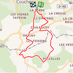

Length
8.1 km

Max alt
390 m

Uphill gradient
189 m
Km-Effort
10.6 km

Min alt
280 m

Downhill gradient
190 m
Boucle
Yes
Creation date :
2019-04-08 11:30:02.202
Updated on :
2019-04-11 19:11:47.67
6h18
Difficulty : Very easy

FREE GPS app for hiking
 SityTrail
IGN / Geographical institutes
SityTrail Plus
The world is yours!
About
Trail Walking of 8.1 km to be discovered at Bourgogne-Franche-Comté, Saône-et-Loire, Couches. This trail is proposed by clabidault.
Positioning
Country:
France
Region :
Bourgogne-Franche-Comté
Department/Province :
Saône-et-Loire
Municipality :
Couches
Location:
Unknown
Start:(Dec)
Start:(UTM)
620499 ; 5191407 (31T) N.
Comments