


190413 ottignies

mguyot
User
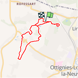

Length
6.8 km

Max alt
119 m

Uphill gradient
94 m
Km-Effort
8 km

Min alt
58 m

Downhill gradient
89 m
Boucle
Yes
Creation date :
2019-04-13 11:36:23.618
Updated on :
2019-04-13 13:12:18.964
1h35
Difficulty : Very easy

FREE GPS app for hiking
 SityTrail
IGN / Geographical institutes
SityTrail Plus
The world is yours!
About
Trail Walking of 6.8 km to be discovered at Wallonia, Walloon Brabant, Ottignies-Louvain-la-Neuve. This trail is proposed by mguyot.
Positioning
Country:
Belgium
Region :
Wallonia
Department/Province :
Walloon Brabant
Municipality :
Ottignies-Louvain-la-Neuve
Location:
Limelette
Start:(Dec)
Start:(UTM)
609691 ; 5615711 (31U) N.
Comments