


9750190-ADAL_16042019_Sceaux

VVerley
User
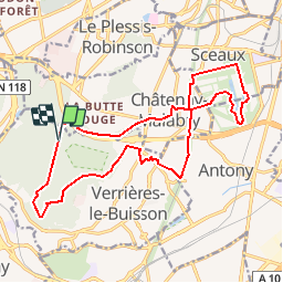

Length
17.5 km

Max alt
181 m

Uphill gradient
256 m
Km-Effort
21 km

Min alt
53 m

Downhill gradient
255 m
Boucle
Yes
Creation date :
2019-04-15 08:17:22.807
Updated on :
2019-04-15 08:20:15.2
4h33
Difficulty : Medium

FREE GPS app for hiking
 SityTrail
IGN / Geographical institutes
SityTrail Plus
The world is yours!
About
Trail Walking of 17.5 km to be discovered at Ile-de-France, Essonne, Verrières-le-Buisson. This trail is proposed by VVerley.
Description
à faire particulièrement mi-Avril pour voir les cerisiers en fleurs au parc de Sceaux !


Positioning
Country:
France
Region :
Ile-de-France
Department/Province :
Essonne
Municipality :
Verrières-le-Buisson
Location:
Unknown
Start:(Dec)
Start:(UTM)
444432 ; 5400997 (31U) N.
Comments