


SityTrail - Mériel 13 km

Djaie60
User
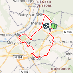

Length
13 km

Max alt
123 m

Uphill gradient
186 m
Km-Effort
15.5 km

Min alt
24 m

Downhill gradient
185 m
Boucle
Yes
Creation date :
2019-04-15 12:53:06.844
Updated on :
2019-04-29 08:52:46.839
3h22
Difficulty : Difficult

FREE GPS app for hiking
 SityTrail
IGN / Geographical institutes
SityTrail Plus
The world is yours!
About
Trail Walking of 13 km to be discovered at Ile-de-France, Val-d'Oise, Villiers-Adam. This trail is proposed by Djaie60.
Positioning
Country:
France
Region :
Ile-de-France
Department/Province :
Val-d'Oise
Municipality :
Villiers-Adam
Location:
Unknown
Start:(Dec)
Start:(UTM)
443125 ; 5435690 (31U) N.
Comments