


Saint Jean Cap ferrat 17/04/2019

Cagolette_lover
User
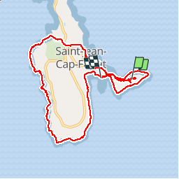

Length
13.4 km

Max alt
49 m

Uphill gradient
274 m
Km-Effort
17.2 km

Min alt
-1 m

Downhill gradient
296 m
Boucle
No
Creation date :
2019-04-17 11:21:28.919
Updated on :
2019-04-17 16:45:59.35
3h54
Difficulty : Very easy

FREE GPS app for hiking
 SityTrail
IGN / Geographical institutes
SityTrail Plus
The world is yours!
About
Trail Walking of 13.4 km to be discovered at Provence-Alpes-Côte d'Azur, Maritime Alps, Saint-Jean-Cap-Ferrat. This trail is proposed by Cagolette_lover.
Description
superbe paysage de bord de mer
Positioning
Country:
France
Region :
Provence-Alpes-Côte d'Azur
Department/Province :
Maritime Alps
Municipality :
Saint-Jean-Cap-Ferrat
Location:
Unknown
Start:(Dec)
Start:(UTM)
366628 ; 4838334 (32T) N.
Comments