


font de mai par le puit de raimu

Coryphene
User
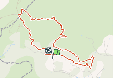

Length
6.5 km

Max alt
450 m

Uphill gradient
279 m
Km-Effort
10.3 km

Min alt
208 m

Downhill gradient
281 m
Boucle
Yes
Creation date :
2019-04-18 08:04:15.57
Updated on :
2019-04-18 13:24:04.296
2h44
Difficulty : Very easy

FREE GPS app for hiking
 SityTrail
IGN / Geographical institutes
SityTrail Plus
The world is yours!
About
Trail Walking of 6.5 km to be discovered at Provence-Alpes-Côte d'Azur, Bouches-du-Rhône, Aubagne. This trail is proposed by Coryphene.
Positioning
Country:
France
Region :
Provence-Alpes-Côte d'Azur
Department/Province :
Bouches-du-Rhône
Municipality :
Aubagne
Location:
Unknown
Start:(Dec)
Start:(UTM)
705709 ; 4798888 (31T) N.
Comments