


J4 18/4 Sauvage--Aumont aubrac

ghislainem
User
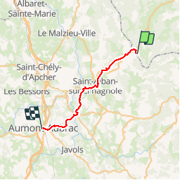

Length
29 km

Max alt
1335 m

Uphill gradient
514 m
Km-Effort
37 km

Min alt
918 m

Downhill gradient
797 m
Boucle
No
Creation date :
2019-04-18 05:59:05.909
Updated on :
2019-04-19 07:12:30.929
10h31
Difficulty : Difficult

FREE GPS app for hiking
 SityTrail
IGN / Geographical institutes
SityTrail Plus
The world is yours!
About
Trail Walking of 29 km to be discovered at Auvergne-Rhône-Alpes, Haute-Loire, Chanaleilles. This trail is proposed by ghislainem.
Positioning
Country:
France
Region :
Auvergne-Rhône-Alpes
Department/Province :
Haute-Loire
Municipality :
Chanaleilles
Location:
Unknown
Start:(Dec)
Start:(UTM)
537105 ; 4963745 (31T) N.
Comments