


Font Giron - La Mure - Nantes en Rattier

maupassant38
User
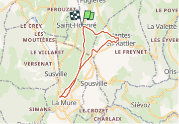

Length
12.7 km

Max alt
972 m

Uphill gradient
232 m
Km-Effort
15.8 km

Min alt
871 m

Downhill gradient
231 m
Boucle
Yes
Creation date :
2019-04-19 08:46:46.334
Updated on :
2019-04-19 14:48:37.002
3h39
Difficulty : Medium

FREE GPS app for hiking
 SityTrail
IGN / Geographical institutes
SityTrail Plus
The world is yours!
About
Trail Walking of 12.7 km to be discovered at Auvergne-Rhône-Alpes, Isère, Saint-Honoré. This trail is proposed by maupassant38.
Positioning
Country:
France
Region :
Auvergne-Rhône-Alpes
Department/Province :
Isère
Municipality :
Saint-Honoré
Location:
Unknown
Start:(Dec)
Start:(UTM)
720871 ; 4980238 (31T) N.
Comments