


aller retour Oyonnax le Lac Genin

cailloux54
User
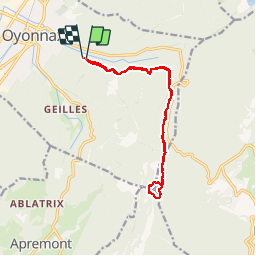

Length
13.7 km

Max alt
975 m

Uphill gradient
523 m
Km-Effort
21 km

Min alt
666 m

Downhill gradient
525 m
Boucle
Yes
Creation date :
2019-04-20 13:17:03.942
Updated on :
2019-04-20 16:50:51.618
3h31
Difficulty : Easy

FREE GPS app for hiking
 SityTrail
IGN / Geographical institutes
SityTrail Plus
The world is yours!
About
Trail Walking of 13.7 km to be discovered at Auvergne-Rhône-Alpes, Ain, Oyonnax. This trail is proposed by cailloux54.
Positioning
Country:
France
Region :
Auvergne-Rhône-Alpes
Department/Province :
Ain
Municipality :
Oyonnax
Location:
Unknown
Start:(Dec)
Start:(UTM)
706120 ; 5125484 (31T) N.
Comments