


florent

DaVinci
User
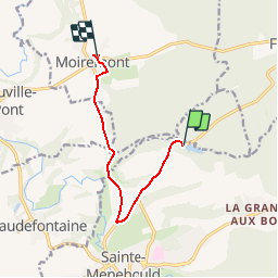

Length
7.7 km

Max alt
191 m

Uphill gradient
105 m
Km-Effort
9.1 km

Min alt
136 m

Downhill gradient
104 m
Boucle
No
Creation date :
2019-04-20 17:18:12.237
Updated on :
2019-04-21 06:39:54.748
2h16
Difficulty : Easy

FREE GPS app for hiking
 SityTrail
IGN / Geographical institutes
SityTrail Plus
The world is yours!
About
Trail Nordic walking of 7.7 km to be discovered at Grand Est, Marne, Sainte-Menehould. This trail is proposed by DaVinci.
Positioning
Country:
France
Region :
Grand Est
Department/Province :
Marne
Municipality :
Sainte-Menehould
Location:
Unknown
Start:(Dec)
Start:(UTM)
639808 ; 5442045 (31U) N.
Comments