


V 2019-Anost

clabidault
User
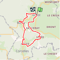

Length
13.9 km

Max alt
573 m

Uphill gradient
406 m
Km-Effort
19.3 km

Min alt
405 m

Downhill gradient
399 m
Boucle
Yes
Creation date :
2019-04-21 07:03:16.285
Updated on :
2019-04-21 14:16:34.27
2h06
Difficulty : Easy

FREE GPS app for hiking
 SityTrail
IGN / Geographical institutes
SityTrail Plus
The world is yours!
About
Trail Walking of 13.9 km to be discovered at Bourgogne-Franche-Comté, Saône-et-Loire, Anost. This trail is proposed by clabidault.
Positioning
Country:
France
Region :
Bourgogne-Franche-Comté
Department/Province :
Saône-et-Loire
Municipality :
Anost
Location:
Unknown
Start:(Dec)
Start:(UTM)
583479 ; 5214350 (31T) N.
Comments