


lucey

PhilippeC54
User
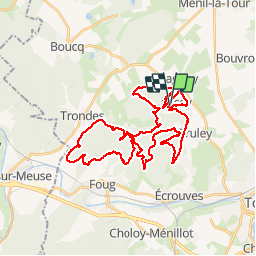

Length
39 km

Max alt
383 m

Uphill gradient
784 m
Km-Effort
50 km

Min alt
248 m

Downhill gradient
783 m
Boucle
Yes
Creation date :
2019-04-22 06:07:09.179
Updated on :
2019-04-22 09:41:33.449
3h26
Difficulty : Very easy

FREE GPS app for hiking
 SityTrail
IGN / Geographical institutes
SityTrail Plus
The world is yours!
About
Trail Mountain bike of 39 km to be discovered at Grand Est, Meurthe-et-Moselle, Lucey. This trail is proposed by PhilippeC54.
Positioning
Country:
France
Region :
Grand Est
Department/Province :
Meurthe-et-Moselle
Municipality :
Lucey
Location:
Unknown
Start:(Dec)
Start:(UTM)
708436 ; 5400216 (31U) N.
Comments