


lachalade

DaVinci
User
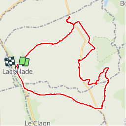

Length
21 km

Max alt
274 m

Uphill gradient
328 m
Km-Effort
25 km

Min alt
145 m

Downhill gradient
328 m
Boucle
Yes
Creation date :
2019-04-22 07:55:01.224
Updated on :
2019-04-22 13:01:32.483
3h42
Difficulty : Medium

FREE GPS app for hiking
 SityTrail
IGN / Geographical institutes
SityTrail Plus
The world is yours!
About
Trail Nordic walking of 21 km to be discovered at Grand Est, Meuse, Lachalade. This trail is proposed by DaVinci.
Positioning
Country:
France
Region :
Grand Est
Department/Province :
Meuse
Municipality :
Lachalade
Location:
Unknown
Start:(Dec)
Start:(UTM)
642811 ; 5447744 (31U) N.
Comments