


hierges

michhhel
User
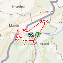

Length
12.1 km

Max alt
244 m

Uphill gradient
299 m
Km-Effort
16.1 km

Min alt
110 m

Downhill gradient
298 m
Boucle
Yes
Creation date :
2019-04-22 08:50:16.018
Updated on :
2019-04-22 13:06:38.61
4h04
Difficulty : Very easy

FREE GPS app for hiking
 SityTrail
IGN / Geographical institutes
SityTrail Plus
The world is yours!
About
Trail Walking of 12.1 km to be discovered at Grand Est, Ardennes, Vireux-Molhain. This trail is proposed by michhhel.
Description
superbe rando. le dernier km est un rien casse-pied, mais le reste est magnifique
Positioning
Country:
France
Region :
Grand Est
Department/Province :
Ardennes
Municipality :
Vireux-Molhain
Location:
Unknown
Start:(Dec)
Start:(UTM)
623436 ; 5549777 (31U) N.
Comments