


Flamanville

phi14
User
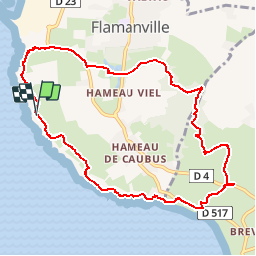

Length
9.3 km

Max alt
83 m

Uphill gradient
197 m
Km-Effort
12 km

Min alt
17 m

Downhill gradient
196 m
Boucle
Yes
Creation date :
2019-04-23 19:07:27.62
Updated on :
2019-04-23 19:08:20.645
2h34
Difficulty : Medium

FREE GPS app for hiking
 SityTrail
IGN / Geographical institutes
SityTrail Plus
The world is yours!
About
Trail Walking of 9.3 km to be discovered at Normandy, Manche, Flamanville. This trail is proposed by phi14.
Positioning
Country:
France
Region :
Normandy
Department/Province :
Manche
Municipality :
Flamanville
Location:
Unknown
Start:(Dec)
Start:(UTM)
580910 ; 5486112 (30U) N.
Comments