


st cheff.

Coux
User

Length
5.3 km

Max alt
417 m

Uphill gradient
115 m
Km-Effort
6.8 km

Min alt
323 m

Downhill gradient
103 m
Boucle
Yes
Creation date :
2019-04-25 08:30:45.499
Updated on :
2019-04-25 09:52:47.91
1h20
Difficulty : Very easy

FREE GPS app for hiking
 SityTrail
IGN / Geographical institutes
SityTrail Plus
The world is yours!
About
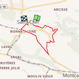
Trail Walking of 5.3 km to be discovered at Auvergne-Rhône-Alpes, Isère, Saint-Chef. This trail is proposed by Coux.
Positioning
Country:
France
Region :
Auvergne-Rhône-Alpes
Department/Province :
Isère
Municipality :
Saint-Chef
Location:
Unknown
Start:(Dec)
Start:(UTM)
684533 ; 5056025 (31T) N.
Comments