


REC Toul

PhilippeC54
User
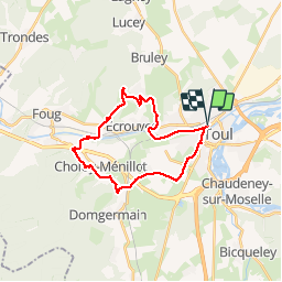

Length
22 km

Max alt
366 m

Uphill gradient
315 m
Km-Effort
27 km

Min alt
208 m

Downhill gradient
316 m
Boucle
Yes
Creation date :
2019-04-24 12:12:19.993
Updated on :
2019-04-25 11:30:02.003
2h01
Difficulty : Very easy

FREE GPS app for hiking
 SityTrail
IGN / Geographical institutes
SityTrail Plus
The world is yours!
About
Trail Mountain bike of 22 km to be discovered at Grand Est, Meurthe-et-Moselle, Toul. This trail is proposed by PhilippeC54.
Positioning
Country:
France
Region :
Grand Est
Department/Province :
Meurthe-et-Moselle
Municipality :
Toul
Location:
Unknown
Start:(Dec)
Start:(UTM)
712514 ; 5395870 (31U) N.
Comments