


Boutevin a/r par viaduc 25 4 2019

RenaudCandottiBesson
User
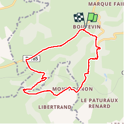

Length
8.3 km

Max alt
493 m

Uphill gradient
200 m
Km-Effort
11 km

Min alt
391 m

Downhill gradient
200 m
Boucle
Yes
Creation date :
2019-04-25 13:59:19.406
Updated on :
2019-04-25 16:17:09.315
2h17
Difficulty : Very easy

FREE GPS app for hiking
 SityTrail
IGN / Geographical institutes
SityTrail Plus
The world is yours!
About
Trail Walking of 8.3 km to be discovered at Auvergne-Rhône-Alpes, Allier, Louroux-de-Bouble. This trail is proposed by RenaudCandottiBesson.
Description
Boutevin Montrognon Doussat Viaduc Boutevin
Positioning
Country:
France
Region :
Auvergne-Rhône-Alpes
Department/Province :
Allier
Municipality :
Louroux-de-Bouble
Location:
Unknown
Start:(Dec)
Start:(UTM)
496867 ; 5120205 (31T) N.
Comments