


6 mai 2019 jour 6

dudu85
User

Length
23 km

Max alt
25 m

Uphill gradient
111 m
Km-Effort
24 km

Min alt
12 m

Downhill gradient
112 m
Boucle
No
Creation date :
2019-04-25 17:06:56.575
Updated on :
2019-04-29 04:45:32.611
3h47
Difficulty : Difficult

FREE GPS app for hiking
 SityTrail
IGN / Geographical institutes
SityTrail Plus
The world is yours!
About
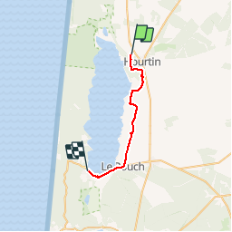
Trail Walking of 23 km to be discovered at New Aquitaine, Gironde, Hourtin. This trail is proposed by dudu85.
Description
Départ Hourtin direction Maubuisson (lac de Carcans)
Distance cumulée 157,6km
Positioning
Country:
France
Region :
New Aquitaine
Department/Province :
Gironde
Municipality :
Hourtin
Location:
Unknown
Start:(Dec)
Start:(UTM)
651228 ; 5006278 (30T) N.
Comments