


croix rousse ,

Coux
User
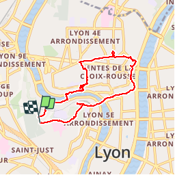

Length
7.2 km

Max alt
305 m

Uphill gradient
259 m
Km-Effort
10.6 km

Min alt
165 m

Downhill gradient
253 m
Boucle
Yes
Creation date :
2019-04-27 07:44:40.505
Updated on :
2019-04-27 09:51:20.56
2h05
Difficulty : Very easy

FREE GPS app for hiking
 SityTrail
IGN / Geographical institutes
SityTrail Plus
The world is yours!
About
Trail Walking of 7.2 km to be discovered at Auvergne-Rhône-Alpes, Métropole de Lyon, Lyon. This trail is proposed by Coux.
Description
ville
Positioning
Country:
France
Region :
Auvergne-Rhône-Alpes
Department/Province :
Métropole de Lyon
Municipality :
Lyon
Location:
Lyon 5e Arrondissement
Start:(Dec)
Start:(UTM)
641008 ; 5069396 (31T) N.
Comments