


Trail Veyrier

gregou74
User
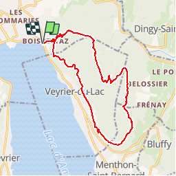

Length
17 km

Max alt
1298 m

Uphill gradient
1238 m
Km-Effort
34 km

Min alt
452 m

Downhill gradient
1238 m
Boucle
Yes
Creation date :
2019-04-27 13:24:05.91
Updated on :
2019-04-27 13:52:51.151
--
Difficulty : Medium

FREE GPS app for hiking
 SityTrail
IGN / Geographical institutes
SityTrail Plus
The world is yours!
About
Trail Trail of 17 km to be discovered at Auvergne-Rhône-Alpes, Upper Savoy, Annecy. This trail is proposed by gregou74.
Positioning
Country:
France
Region :
Auvergne-Rhône-Alpes
Department/Province :
Upper Savoy
Municipality :
Annecy
Location:
Annecy-le-Vieux
Start:(Dec)
Start:(UTM)
279690 ; 5087293 (32T) N.
Comments