


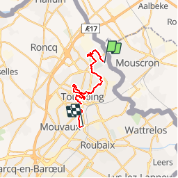
TOURCOING PARCS ET JARDINS

dehemjacques
User

Length
13.9 km

Max alt
54 m

Uphill gradient
86 m
Km-Effort
15.1 km

Min alt
33 m

Downhill gradient
90 m
Boucle
No
Creation date :
2019-04-27 14:19:02.29
Updated on :
2019-04-27 14:20:08.038
3h21
Difficulty : Difficult

FREE GPS app for hiking
 SityTrail
IGN / Geographical institutes
SityTrail Plus
The world is yours!
About
Trail Walking of 13.9 km to be discovered at Hauts-de-France, Nord, Tourcoing. This trail is proposed by dehemjacques.
Description
Départ Métro Hopital DRON - Arrivée métro station Mercure
Positioning
Country:
France
Region :
Hauts-de-France
Department/Province :
Nord
Municipality :
Tourcoing
Location:
Unknown
Start:(Dec)
Start:(UTM)
512776 ; 5621286 (31U) N.
Comments