


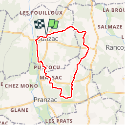
La rando du comité des fêtes de Bunzac 2019

alainjoseph6
User

Length
12.9 km

Max alt
135 m

Uphill gradient
161 m
Km-Effort
15.1 km

Min alt
80 m

Downhill gradient
161 m
Boucle
Yes
Creation date :
2019-04-28 06:06:18.052
Updated on :
2019-04-28 10:28:14.916
4h20
Difficulty : Easy

FREE GPS app for hiking
 SityTrail
IGN / Geographical institutes
SityTrail Plus
The world is yours!
About
Trail Walking of 12.9 km to be discovered at New Aquitaine, Charente, Bunzac. This trail is proposed by alainjoseph6.
Description
Une rando très agréable sans partie goudronnée qui chemine sur trois communes. Bunzac, Rancogne, Pranzac.
Positioning
Country:
France
Region :
New Aquitaine
Department/Province :
Charente
Municipality :
Bunzac
Location:
Unknown
Start:(Dec)
Start:(UTM)
293810 ; 5064397 (31T) N.
Comments