


st p la Palud

Coux
User
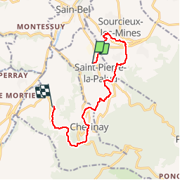

Length
11.6 km

Max alt
599 m

Uphill gradient
431 m
Km-Effort
17.3 km

Min alt
299 m

Downhill gradient
436 m
Boucle
No
Creation date :
2019-04-28 07:21:52.048
Updated on :
2019-04-28 11:16:48.109
3h53
Difficulty : Easy

FREE GPS app for hiking
 SityTrail
IGN / Geographical institutes
SityTrail Plus
The world is yours!
About
Trail Walking of 11.6 km to be discovered at Auvergne-Rhône-Alpes, Rhône, Saint-Pierre-la-Palud. This trail is proposed by Coux.
Positioning
Country:
France
Region :
Auvergne-Rhône-Alpes
Department/Province :
Rhône
Municipality :
Saint-Pierre-la-Palud
Location:
Unknown
Start:(Dec)
Start:(UTM)
625058 ; 5072158 (31T) N.
Comments