


Le tour de Calisso

Daron34
User
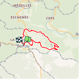

Length
12.7 km

Max alt
371 m

Uphill gradient
415 m
Km-Effort
18.3 km

Min alt
133 m

Downhill gradient
422 m
Boucle
Yes
Creation date :
2019-04-30 05:57:21.211
Updated on :
2019-04-30 05:57:21.211

FREE GPS app for hiking
 SityTrail
IGN / Geographical institutes
SityTrail Plus
The world is yours!
About
Trail of 12.7 km to be discovered at Occitania, Hérault, Berlou. This trail is proposed by Daron34.
Points of interest


Positioning
Country:
France
Region :
Occitania
Department/Province :
Hérault
Municipality :
Berlou
Location:
Unknown
Start:(Dec)
Start:(UTM)
496736 ; 4815320 (31T) N.
Comments