


randogps11-302

Daron34
User
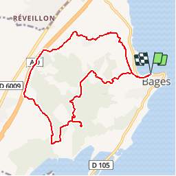

Length
9.8 km

Max alt
107 m

Uphill gradient
204 m
Km-Effort
12.5 km

Min alt
2 m

Downhill gradient
204 m
Boucle
Yes
Creation date :
2019-04-30 06:09:29.127
Updated on :
2019-04-30 06:16:09.896
2h41
Difficulty : Medium

FREE GPS app for hiking
 SityTrail
IGN / Geographical institutes
SityTrail Plus
The world is yours!
About
Trail Walking of 9.8 km to be discovered at Occitania, Aude, Bages. This trail is proposed by Daron34.
Description
Sur les hauteurs de bages via pesquis
Positioning
Country:
France
Region :
Occitania
Department/Province :
Aude
Municipality :
Bages
Location:
Unknown
Start:(Dec)
Start:(UTM)
499276 ; 4774674 (31T) N.
Comments