


20190429-Forêt de Bord

doudet
User
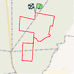

Length
8.2 km

Max alt
139 m

Uphill gradient
95 m
Km-Effort
9.5 km

Min alt
74 m

Downhill gradient
95 m
Boucle
Yes
Creation date :
2019-04-30 07:35:46.133
Updated on :
2019-05-02 06:00:18.25
2h07
Difficulty : Very easy

FREE GPS app for hiking
 SityTrail
IGN / Geographical institutes
SityTrail Plus
The world is yours!
About
Trail Walking of 8.2 km to be discovered at Normandy, Eure, Les Damps. This trail is proposed by doudet.
Description
Boucle A-R au départ du Parcours sportif des Damps
Positioning
Country:
France
Region :
Normandy
Department/Province :
Eure
Municipality :
Les Damps
Location:
Unknown
Start:(Dec)
Start:(UTM)
367210 ; 5461026 (31U) N.
Comments