


TRK000

Djaie60
User
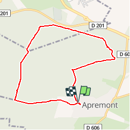

Length
8.4 km

Max alt
134 m

Uphill gradient
126 m
Km-Effort
10.1 km

Min alt
71 m

Downhill gradient
130 m
Boucle
Yes
Creation date :
2019-05-01 14:40:21.435
Updated on :
2019-05-01 14:52:37.379
2h12
Difficulty : Medium

FREE GPS app for hiking
 SityTrail
IGN / Geographical institutes
SityTrail Plus
The world is yours!
About
Trail Walking of 8.4 km to be discovered at Hauts-de-France, Oise, Apremont. This trail is proposed by Djaie60.
Positioning
Country:
France
Region :
Hauts-de-France
Department/Province :
Oise
Municipality :
Apremont
Location:
Unknown
Start:(Dec)
Start:(UTM)
463880 ; 5452615 (31U) N.
Comments