


TOLERME 14.4 km

ZAMBAUX
User
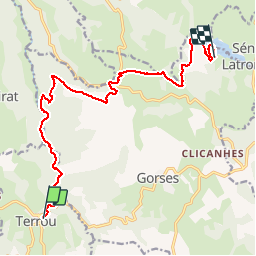

Length
14.4 km

Max alt
631 m

Uphill gradient
490 m
Km-Effort
20 km

Min alt
262 m

Downhill gradient
310 m
Boucle
No
Creation date :
2019-05-01 18:47:43.774
Updated on :
2019-05-01 18:48:39.56
4h23
Difficulty : Very difficult

FREE GPS app for hiking
 SityTrail
IGN / Geographical institutes
SityTrail Plus
The world is yours!
About
Trail Walking of 14.4 km to be discovered at Occitania, Lot, Terrou. This trail is proposed by ZAMBAUX.
Description
Semaine de Marche
Positioning
Country:
France
Region :
Occitania
Department/Province :
Lot
Municipality :
Terrou
Location:
Unknown
Start:(Dec)
Start:(UTM)
419715 ; 4959488 (31T) N.
Comments