


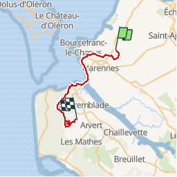
02-05-2019 2 journée 35,6km

dudu85
User

Length
32 km
Boucle
No
Creation date :
2019-05-02 07:25:52.0
Updated on :
2019-05-02 15:32:31.319
7h31
Difficulty : Unknown

FREE GPS app for hiking
 SityTrail
IGN / Geographical institutes
SityTrail Plus
The world is yours!
About
Trail Walking of 32 km to be discovered at New Aquitaine, Charente-Maritime, Marennes-Hiers-Brouage. This trail is proposed by dudu85.
Description
Deuxième journée. Petit soucis rencontré ! Routin fermé par grillage donc détour et supplément de 4,6km
Photos

Positioning
Country:
France
Region :
New Aquitaine
Department/Province :
Charente-Maritime
Municipality :
Marennes-Hiers-Brouage
Location:
Unknown
Start:(Dec)
Start:(UTM)
649333 ; 5078727 (30T) N.
Comments