


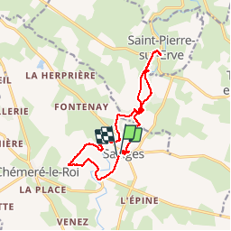
Saulges -Grottes Margot - Moulins - Oratoire de Saint-Ceneré

MichelRando7656
User

Length
14.7 km

Max alt
102 m

Uphill gradient
215 m
Km-Effort
17.5 km

Min alt
52 m

Downhill gradient
211 m
Boucle
Yes
Creation date :
2019-05-02 08:04:17.416
Updated on :
2019-05-02 16:13:28.696
8h07
Difficulty : Medium

FREE GPS app for hiking
 SityTrail
IGN / Geographical institutes
SityTrail Plus
The world is yours!
About
Trail Walking of 14.7 km to be discovered at Pays de la Loire, Mayenne, Saulges. This trail is proposed by MichelRando7656.
Description
Belles promenades par les superbes sentiers Mayennais- Beaux moulins et panoramas splendides.
Photos


Positioning
Country:
France
Region :
Pays de la Loire
Department/Province :
Mayenne
Municipality :
Saulges
Location:
Unknown
Start:(Dec)
Start:(UTM)
693406 ; 5317613 (30T) N.
Comments