


Vannes sur cosson et ses trognards

lemuid
User
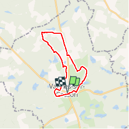

Length
11.3 km

Max alt
149 m

Uphill gradient
66 m
Km-Effort
12.2 km

Min alt
127 m

Downhill gradient
66 m
Boucle
Yes
Creation date :
2019-05-05 07:07:52.939
Updated on :
2019-05-05 16:37:08.46
2h28
Difficulty : Very easy

FREE GPS app for hiking
 SityTrail
IGN / Geographical institutes
SityTrail Plus
The world is yours!
About
Trail Walking of 11.3 km to be discovered at Centre-Loire Valley, Loiret, Vannes-sur-Cosson. This trail is proposed by lemuid.
Positioning
Country:
France
Region :
Centre-Loire Valley
Department/Province :
Loiret
Municipality :
Vannes-sur-Cosson
Location:
Unknown
Start:(Dec)
Start:(UTM)
440846 ; 5284750 (31T) N.
Comments