


Champrougier

TRIMAILLE
User
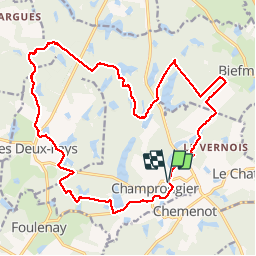

Length
22 km

Max alt
250 m

Uphill gradient
213 m
Km-Effort
25 km

Min alt
202 m

Downhill gradient
211 m
Boucle
Yes
Creation date :
2019-05-05 07:38:50.909
Updated on :
2019-05-05 13:57:22.78
5h35
Difficulty : Very easy

FREE GPS app for hiking
 SityTrail
IGN / Geographical institutes
SityTrail Plus
The world is yours!
About
Trail Walking of 22 km to be discovered at Bourgogne-Franche-Comté, Jura, Champrougier. This trail is proposed by TRIMAILLE.
Photos


Positioning
Country:
France
Region :
Bourgogne-Franche-Comté
Department/Province :
Jura
Municipality :
Champrougier
Location:
Unknown
Start:(Dec)
Start:(UTM)
692595 ; 5194206 (31T) N.
Comments