


MontStJeanSudEst

jeanboulay
User

Length
22 km

Max alt
556 m

Uphill gradient
367 m
Km-Effort
27 km

Min alt
398 m

Downhill gradient
368 m
Boucle
Yes
Creation date :
2019-05-05 15:33:39.485
Updated on :
2019-05-05 15:57:25.741
1h49
Difficulty : Medium

FREE GPS app for hiking
 SityTrail
IGN / Geographical institutes
SityTrail Plus
The world is yours!
About
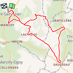
Trail Mountain bike of 22 km to be discovered at Bourgogne-Franche-Comté, Côte-d'Or, Mont-Saint-Jean. This trail is proposed by jeanboulay.
Positioning
Country:
France
Region :
Bourgogne-Franche-Comté
Department/Province :
Côte-d'Or
Municipality :
Mont-Saint-Jean
Location:
Unknown
Start:(Dec)
Start:(UTM)
606066 ; 5238724 (31T) N.
Comments