


V2019- Autun

clabidault
User
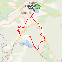

Length
13.7 km

Max alt
600 m

Uphill gradient
334 m
Km-Effort
18.1 km

Min alt
315 m

Downhill gradient
334 m
Boucle
Yes
Creation date :
2019-05-06 11:46:30.931
Updated on :
2019-05-13 19:16:07.562
--
Difficulty : Easy

FREE GPS app for hiking
 SityTrail
IGN / Geographical institutes
SityTrail Plus
The world is yours!
About
Trail On foot of 13.7 km to be discovered at Bourgogne-Franche-Comté, Saône-et-Loire, Autun. This trail is proposed by clabidault.
Positioning
Country:
France
Region :
Bourgogne-Franche-Comté
Department/Province :
Saône-et-Loire
Municipality :
Autun
Location:
Saint-Pantaléon
Start:(Dec)
Start:(UTM)
599801 ; 5200588 (31T) N.
Comments