


st chely - ste come

norihtom
User
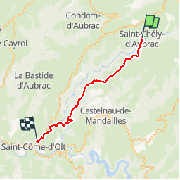

Length
19.5 km

Max alt
925 m

Uphill gradient
332 m
Km-Effort
25 km

Min alt
383 m

Downhill gradient
767 m
Boucle
No
Creation date :
2014-12-10 00:00:00.0
Updated on :
2014-12-10 00:00:00.0
5h32
Difficulty : Medium

FREE GPS app for hiking
 SityTrail
IGN / Geographical institutes
SityTrail Plus
The world is yours!
About
Trail Walking of 19.5 km to be discovered at Occitania, Aveyron, Saint-Chély-d'Aubrac. This trail is proposed by norihtom.
Positioning
Country:
France
Region :
Occitania
Department/Province :
Aveyron
Municipality :
Saint-Chély-d'Aubrac
Location:
Unknown
Start:(Dec)
Start:(UTM)
493820 ; 4937524 (31T) N.
Comments