


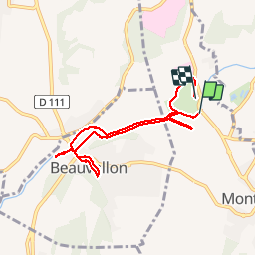
Le parc de Lorient ( Montéléger) 2019

raygautier
User

Length
7.1 km

Max alt
140 m

Uphill gradient
66 m
Km-Effort
8 km

Min alt
117 m

Downhill gradient
65 m
Boucle
No
Creation date :
2019-05-06 14:17:36.0
Updated on :
2019-05-06 18:14:55.186
1h53
Difficulty : Unknown

FREE GPS app for hiking
 SityTrail
IGN / Geographical institutes
SityTrail Plus
The world is yours!
About
Trail Walking of 7.1 km to be discovered at Auvergne-Rhône-Alpes, Drôme, Montéléger. This trail is proposed by raygautier.
Description
Balade sympa
Photos
 2019 - Photo 1")
Positioning
Country:
France
Region :
Auvergne-Rhône-Alpes
Department/Province :
Drôme
Municipality :
Montéléger
Location:
Unknown
Start:(Dec)
Start:(UTM)
651852 ; 4969621 (31T) N.
Comments