


Valgorge le sentier des gardes

ajasse
User
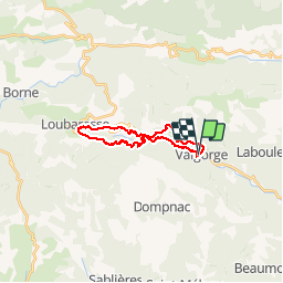

Length
20 km

Max alt
1173 m

Uphill gradient
809 m
Km-Effort
31 km

Min alt
534 m

Downhill gradient
805 m
Boucle
Yes
Creation date :
2019-05-06 08:04:31.985
Updated on :
2019-05-06 21:04:22.522
7h59
Difficulty : Very easy

FREE GPS app for hiking
 SityTrail
IGN / Geographical institutes
SityTrail Plus
The world is yours!
About
Trail Walking of 20 km to be discovered at Auvergne-Rhône-Alpes, Ardèche, Valgorge. This trail is proposed by ajasse.
Positioning
Country:
France
Region :
Auvergne-Rhône-Alpes
Department/Province :
Ardèche
Municipality :
Valgorge
Location:
Unknown
Start:(Dec)
Start:(UTM)
589399 ; 4937696 (31T) N.
Comments