


LA BIGNETTE

UDGI54
User
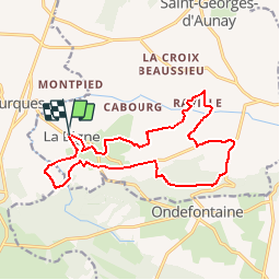

Length
15.1 km

Max alt
259 m

Uphill gradient
317 m
Km-Effort
19.4 km

Min alt
138 m

Downhill gradient
319 m
Boucle
Yes
Creation date :
2019-05-08 13:54:23.818
Updated on :
2019-05-08 14:05:54.604
4h09
Difficulty : Difficult

FREE GPS app for hiking
 SityTrail
IGN / Geographical institutes
SityTrail Plus
The world is yours!
About
Trail Walking of 15.1 km to be discovered at Normandy, Calvados, Seulline. This trail is proposed by UDGI54.
Positioning
Country:
France
Region :
Normandy
Department/Province :
Calvados
Municipality :
Seulline
Location:
La Bigne
Start:(Dec)
Start:(UTM)
666430 ; 5431324 (30U) N.
Comments