


GIVRAI 14:51:59

UDGI54
User
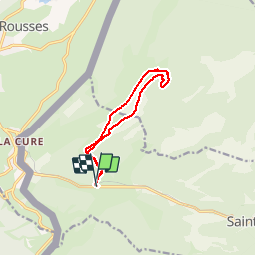

Length
10.1 km

Max alt
1508 m

Uphill gradient
361 m
Km-Effort
14.9 km

Min alt
1206 m

Downhill gradient
370 m
Boucle
Yes
Creation date :
2019-05-08 14:17:06.6
Updated on :
2019-05-08 14:34:35.164

FREE GPS app for hiking
 SityTrail
IGN / Geographical institutes
SityTrail Plus
The world is yours!
About
Trail of 10.1 km to be discovered at Vaud, District de Nyon, Saint-Cergue. This trail is proposed by UDGI54.
Positioning
Country:
Switzerland
Region :
Vaud
Department/Province :
District de Nyon
Municipality :
Saint-Cergue
Location:
Unknown
Start:(Dec)
Start:(UTM)
277269 ; 5148653 (32T) N.
Comments