


GTDV-J2

PhilippeC54
User
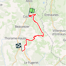

Length
41 km

Max alt
2469 m

Uphill gradient
1721 m
Km-Effort
63 km

Min alt
1246 m

Downhill gradient
1537 m
Boucle
No
Creation date :
2019-05-09 15:14:28.567
Updated on :
2019-05-09 15:14:28.567
--
Difficulty : Unknown

FREE GPS app for hiking
 SityTrail
IGN / Geographical institutes
SityTrail Plus
The world is yours!
About
Trail Mountain bike of 41 km to be discovered at Provence-Alpes-Côte d'Azur, Alpes-de-Haute-Provence, Colmars. This trail is proposed by PhilippeC54.
Positioning
Country:
France
Region :
Provence-Alpes-Côte d'Azur
Department/Province :
Alpes-de-Haute-Provence
Municipality :
Colmars
Location:
Unknown
Start:(Dec)
Start:(UTM)
310259 ; 4894789 (32T) N.
Comments