


GTDV-J3

PhilippeC54
User
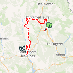

Length
48 km

Max alt
1766 m

Uphill gradient
1397 m
Km-Effort
69 km

Min alt
896 m

Downhill gradient
1904 m
Boucle
No
Creation date :
2019-05-09 15:14:31.516
Updated on :
2019-05-09 15:14:31.516
--
Difficulty : Unknown

FREE GPS app for hiking
 SityTrail
IGN / Geographical institutes
SityTrail Plus
The world is yours!
About
Trail Mountain bike of 48 km to be discovered at Provence-Alpes-Côte d'Azur, Alpes-de-Haute-Provence, Thorame-Haute. This trail is proposed by PhilippeC54.
Positioning
Country:
France
Region :
Provence-Alpes-Côte d'Azur
Department/Province :
Alpes-de-Haute-Provence
Municipality :
Thorame-Haute
Location:
Unknown
Start:(Dec)
Start:(UTM)
307173 ; 4879900 (32T) N.
Comments