


GTDV-J4

PhilippeC54
User

Length
42 km

Max alt
1317 m

Uphill gradient
1321 m
Km-Effort
60 km

Min alt
713 m

Downhill gradient
1281 m
Boucle
No
Creation date :
2019-05-09 15:14:36.308
Updated on :
2019-05-09 15:14:36.308
--
Difficulty : Unknown

FREE GPS app for hiking
 SityTrail
IGN / Geographical institutes
SityTrail Plus
The world is yours!
About
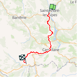
Trail Mountain bike of 42 km to be discovered at Provence-Alpes-Côte d'Azur, Alpes-de-Haute-Provence, Saint-André-les-Alpes. This trail is proposed by PhilippeC54.
Positioning
Country:
France
Region :
Provence-Alpes-Côte d'Azur
Department/Province :
Alpes-de-Haute-Provence
Municipality :
Saint-André-les-Alpes
Location:
Unknown
Start:(Dec)
Start:(UTM)
299715 ; 4871141 (32T) N.
Comments