


Nolay La Cascade page 147

grasgilbert
User
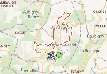

Length
18 km

Max alt
518 m

Uphill gradient
555 m
Km-Effort
25 km

Min alt
327 m

Downhill gradient
554 m
Boucle
Yes
Creation date :
2019-05-09 07:12:36.771
Updated on :
2021-08-05 15:01:50.817
5h58
Difficulty : Difficult

FREE GPS app for hiking
 SityTrail
IGN / Geographical institutes
SityTrail Plus
The world is yours!
About
Trail Walking of 18 km to be discovered at Bourgogne-Franche-Comté, Côte-d'Or, Nolay. This trail is proposed by grasgilbert.
Description
La Cascade
Positioning
Country:
France
Region :
Bourgogne-Franche-Comté
Department/Province :
Côte-d'Or
Municipality :
Nolay
Location:
Unknown
Start:(Dec)
Start:(UTM)
624587 ; 5200776 (31T) N.
Comments