Trail Walking Amiens - SityTrail - 103560 - amiens-samara - Photo

SityTrail - 103560 - amiens-samara

 doudet
doudet

User

© OpenStreetMap contributors
Length
Length
24 km
Max alt
Max alt
62 m
Uphill gradient
Uphill gradient
161 m
Km-Effort
Km-Effort  
26 km
Min alt
Min alt
12 m
Downhill gradient
Downhill gradient
161 m
Boucle
Boucle
Yes
Creation date :
2019-05-10 06:04:11.802
Updated on :
2019-05-10 06:07:11.102

(0 Reviews)

Walking
Walking
--
Difficulty : Unknown

Scan this QR Code to open this trail in the SityTrail application

FREE GPS app for hiking

Logo SityTrail SityTrail

IGN / Geographical institutes

Download SityTrail from the App Store Download SityTrail from Google Play

Logo SityTrail SityTrail Plus

The world is yours!

Download SityTrail from the App Store Download SityTrail from Google Play Download SityTrail on Huawei AppGallery

About

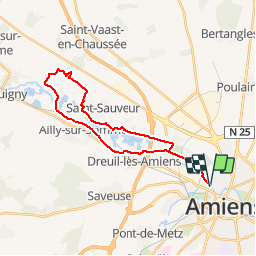
Trail Walking of 24 km to be discovered at Hauts-de-France, Somme, Amiens. This trail is proposed by doudet.

Description

Belle boucle, paysages variés (Bois, champs, chemin de hallage...), 25 km que l'on peut raccourcir très facilement (100 m sur une petite route). Samara est le nom gaulois de la Somme, le fleuve qui traverse le département et qui a donné son nom à la ville d'Amiens. Situé à 15 km de la ville, le parc de Samara est aujourd'hui le plus grand archéosite du nord de la France. (Note Tracegps)

Elevation profile

Positioning

Country:
France
Region :
Hauts-de-France
Department/Province :
Somme
Municipality :
Amiens
Location:
Unknown
Start:(UTM)
448753 ; 5528130 (31U) N.


Close
My subscriptions