


St valerin

LUCIE2016
User
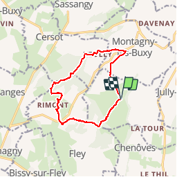

Length
12 km

Max alt
463 m

Uphill gradient
308 m
Km-Effort
16.1 km

Min alt
279 m

Downhill gradient
307 m
Boucle
Yes
Creation date :
2019-05-10 11:39:02.93
Updated on :
2019-05-11 16:54:05.065
2h38
Difficulty : Very easy

FREE GPS app for hiking
 SityTrail
IGN / Geographical institutes
SityTrail Plus
The world is yours!
About
Trail Walking of 12 km to be discovered at Bourgogne-Franche-Comté, Saône-et-Loire, Saint-Vallerin. This trail is proposed by LUCIE2016.
Positioning
Country:
France
Region :
Bourgogne-Franche-Comté
Department/Province :
Saône-et-Loire
Municipality :
Saint-Vallerin
Location:
Unknown
Start:(Dec)
Start:(UTM)
627135 ; 5171859 (31T) N.
Comments