


Jean Sarment Butry

avdem
User
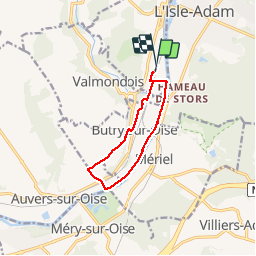

Length
8.4 km

Max alt
69 m

Uphill gradient
83 m
Km-Effort
9.6 km

Min alt
20 m

Downhill gradient
82 m
Boucle
Yes
Creation date :
2019-05-13 07:33:07.769
Updated on :
2019-05-13 10:00:20.6
2h26
Difficulty : Very easy

FREE GPS app for hiking
 SityTrail
IGN / Geographical institutes
SityTrail Plus
The world is yours!
About
Trail Walking of 8.4 km to be discovered at Ile-de-France, Val-d'Oise, Parmain. This trail is proposed by avdem.
Description
Cool si lundi
Positioning
Country:
France
Region :
Ile-de-France
Department/Province :
Val-d'Oise
Municipality :
Parmain
Location:
Unknown
Start:(Dec)
Start:(UTM)
441977 ; 5438744 (31U) N.
Comments