


SityTrail - 2014-01-06 Rando Boissy

c.chehere
User
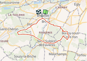

Length
15.2 km

Max alt
158 m

Uphill gradient
257 m
Km-Effort
18.6 km

Min alt
56 m

Downhill gradient
257 m
Boucle
Yes
Creation date :
2019-05-13 11:25:45.898
Updated on :
2024-11-01 05:19:33.253
4h13
Difficulty : Difficult

FREE GPS app for hiking
 SityTrail
IGN / Geographical institutes
SityTrail Plus
The world is yours!
About
Trail Walking of 15.2 km to be discovered at Ile-de-France, Essonne, Breuillet. This trail is proposed by c.chehere.
Description
Depuis la gare de Breuillet RER C
Positioning
Country:
France
Region :
Ile-de-France
Department/Province :
Essonne
Municipality :
Breuillet
Location:
Unknown
Start:(Dec)
Start:(UTM)
438896 ; 5379426 (31U) N.
Comments